
Carte topographique Tackaberry Lake
Carte interactive
Cliquez sur la carte pour afficher l’altitude.
À propos de cette carte
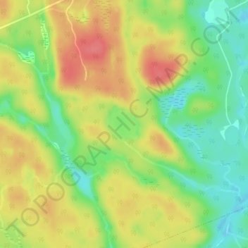
Nom : Carte topographique Tackaberry Lake, altitude, relief.
Altitude moyenne : 338 m
Altitude minimum : 304 m
Altitude maximum : 370 m
Autres cartes topographiques
Cliquez sur une carte pour visualiser sa topographie, son altitude et son relief.
Limberlost Forest and Wildlife Reserve
Canada > Ontario > Muskoka District > Lake of Bays Township
Limberlost Forest and Wildlife Reserve, Lake of Bays Township, District Municipality of Muskoka, Muskoka District, Central Ontario, Ontario, Canada
Altitude moyenne : 400 m
Dwight
Canada > Ontario > Muskoka District > Lake of Bays Township
Dwight, Lake of Bays Township, District Municipality of Muskoka, Muskoka District, Central Ontario, Ontario, Canada
Altitude moyenne : 341 m