
Carte topographique Westchester
Carte interactive
Cliquez sur la carte pour afficher l’altitude.
À propos de cette carte
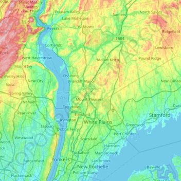
Nom : Carte topographique Westchester, altitude, relief.
Lieu : Westchester, New York, United States of America (40.87172 -73.98328 41.36638 -73.48270)
Altitude moyenne : 95 m
Altitude minimum : -1 m
Altitude maximum : 421 m
At 987 feet (301 m), the highest elevation in the county is a U.S. Coast and Geodetic Survey benchmark known as "Bailey" in Mountain Lakes Park near the Connecticut state line. The lowest elevation is sea level, along both the Hudson and Long Island Sound.
Autres cartes topographiques
Cliquez sur une carte pour visualiser sa topographie, son altitude et son relief.
Yaphank
United States of America > New York > Yaphank
Yaphank, Suffolk, New York, 11980, United States of America
Altitude moyenne : 24 m
Saratoga County
United States of America > New York
Saratoga County, New York, United States of America
Altitude moyenne : 218 m
Essex County
United States of America > New York
Essex County, New York, United States of America
Altitude moyenne : 418 m
Farmingville
United States of America > New York > Farmingville
Farmingville, Suffolk, New York, 11738, United States of America
Altitude moyenne : 47 m
Syracuse
United States of America > New York > Syracuse
Syracuse, Onondaga County, New York, United States of America
Altitude moyenne : 172 m
Honeymoon Island
United States of America > New York
Honeymoon Island, Franklin County, New York, United States of America
Altitude moyenne : 489 m
Riverhead
United States of America > New York > Riverhead
Riverhead, Suffolk County, New York, United States of America
Altitude moyenne : 13 m
Barrytown
United States of America > New York > Barrytown
Barrytown, Town of Red Hook, Dutchess, New York, 12507, United States of America
Altitude moyenne : 34 m
Sullivan County
United States of America > New York
Sullivan County, New York, United States of America
Altitude moyenne : 435 m
Chenango County
United States of America > New York
Chenango County, New York, United States of America
Altitude moyenne : 442 m
Niagara County
United States of America > New York
Niagara County, New York, United States of America
Altitude moyenne : 137 m
Saint Lawrence County
United States of America > New York
Saint Lawrence County, New York, United States of America
Altitude moyenne : 239 m
Nassau County
United States of America > New York
Nassau County, New York, United States of America
Altitude moyenne : 18 m
Niagara Falls
United States of America > New York > Niagara Falls
Niagara Falls, Niagara County, New York, United States of America
Altitude moyenne : 180 m