
Carte topographique Iron Belt
Carte interactive
Cliquez sur la carte pour afficher l’altitude.
À propos de cette carte
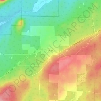
Nom : Carte topographique Iron Belt, altitude, relief.
Altitude moyenne : 475 m
Altitude minimum : 419 m
Altitude maximum : 534 m
Autres cartes topographiques
Cliquez sur une carte pour visualiser sa topographie, son altitude et son relief.
Montreal
United States > Wisconsin > Iron County
Montreal, Iron County, Wisconsin, United States
Altitude moyenne : 464 m
Town of Gurney
United States > Wisconsin > Iron County
Town of Gurney, Iron County, Wisconsin, United States
Altitude moyenne : 318 m
Powell
United States > Wisconsin > Iron County
Powell, Town of Sherman, Iron County, Wisconsin, United States
Altitude moyenne : 487 m
Town of Pence
United States > Wisconsin > Iron County
Town of Pence, Iron County, Wisconsin, United States
Altitude moyenne : 485 m
Saxon
United States > Wisconsin > Iron County
Saxon, Town of Saxon, Iron County, Wisconsin, 54559, United States
Altitude moyenne : 339 m
Payment Lake
United States > Wisconsin > Iron County > Town of Mercer
Payment Lake, Town of Mercer, Iron County, Wisconsin, United States
Altitude moyenne : 495 m
Upson
United States > Wisconsin > Iron County
Upson, Town of Anderson, Iron County, Wisconsin, United States
Altitude moyenne : 462 m
Hurley
United States > Wisconsin > Iron County
Hurley, Iron County, Wisconsin, United States
Altitude moyenne : 455 m
Town of Anderson
United States > Wisconsin > Iron County
Town of Anderson, Iron County, Wisconsin, United States
Altitude moyenne : 467 m
Town of Mercer
United States > Wisconsin > Iron County
Town of Mercer, Iron County, Wisconsin, 54547, United States
Altitude moyenne : 493 m
Manitowish River
United States > Wisconsin > Iron County > Town of Mercer > Manitowish
Manitowish River, Manitowish, Town of Mercer, Iron County, Wisconsin, United States
Altitude moyenne : 486 m