
Carte topographique Hart-Miller Island
Carte interactive
Cliquez sur la carte pour afficher l’altitude.
À propos de cette carte
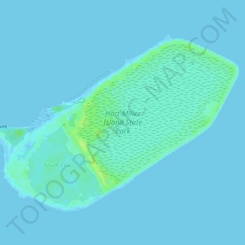
Nom : Carte topographique Hart-Miller Island, altitude, relief.
Lieu : Hart-Miller Island, Towson, Baltimore County, Maryland, USA (39.23777 -76.38660 39.26174 -76.34401)
Altitude moyenne : 2 m
Altitude minimum : -2 m
Altitude maximum : 13 m
Autres cartes topographiques
Cliquez sur une carte pour visualiser sa topographie, son altitude et son relief.
Loch Raven Reservoir
Loch Raven Reservoir, Dulaney Valley Road, Towson, Baltimore County, Maryland, 21093, USA
Altitude moyenne : 113 m
Mingo Branch
United States > Maryland > Towson
Mingo Branch, Baltimore County, Maryland, 21120, United States
Altitude moyenne : 173 m
The Bunker
The Bunker, Towson, Baltimore County, Maryland, USA
Altitude moyenne : 152 m
Cromwell Valley Park
Cromwell Valley Park, Satyr Hill Estates, Towson, Baltimore County, Maryland, USA
Altitude moyenne : 106 m