
Carte topographique Niagara River
Carte interactive
Cliquez sur la carte pour afficher l’altitude.
À propos de cette carte
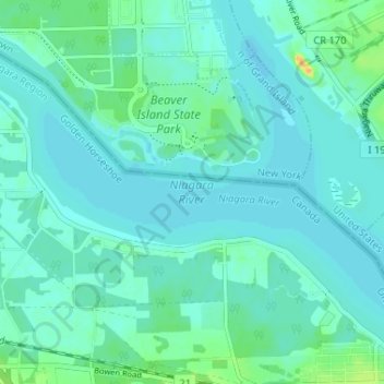
Nom : Carte topographique Niagara River, altitude, relief.
Altitude moyenne : 177 m
Altitude minimum : 171 m
Altitude maximum : 203 m
The river, which is occasionally described as a strait, is about 58 kilometres (36 mi) long and includes Niagara Falls in its course. The falls have moved approximately 11 kilometres (6.8 mi) upstream from the Niagara Escarpment in the last 12,000 years, resulting in a gorge below the falls. Today, the diversion of the river for electrical generation has significantly reduced the rate of erosion. The total drop in elevation along the river is 99 metres (325 ft). The Niagara Gorge extends downstream from the Falls and includes the Niagara Whirlpool and another section of rapids.
Autres cartes topographiques
Cliquez sur une carte pour visualiser sa topographie, son altitude et son relief.
Crystal Beach
Canada > Ontario > Niagara Region > Fort Erie
Crystal Beach, Fort Erie, Niagara Region, Golden Horseshoe, Ontario, L0S 1B0, Canada
Altitude moyenne : 181 m
Fort Erie
Canada > Ontario > Niagara Region > Fort Erie
Fort Erie, Niagara Region, Golden Horseshoe, Ontario, L2A 3S7, Canada
Altitude moyenne : 183 m
Stevensville
Canada > Ontario > Niagara Region > Fort Erie > Stevensville
Stevensville, Fort Erie, Niagara Region, Golden Horseshoe, Ontario, Canada
Altitude moyenne : 178 m