
Carte topographique Maasin
Carte interactive
Cliquez sur la carte pour afficher l’altitude.
À propos de cette carte
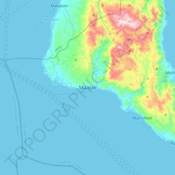
Nom : Carte topographique Maasin, altitude, relief.
Lieu : Maasin, Southern Leyte, Eastern Visayas, Philippines (9.97251 124.67851 10.29251 124.99851)
Altitude moyenne : 90 m
Altitude minimum : 0 m
Altitude maximum : 687 m
Autres cartes topographiques
Cliquez sur une carte pour visualiser sa topographie, son altitude et son relief.
Canlupao
Canlupao, Southern Leyte, Eastern Visayas, 6605, Philippines
Altitude moyenne : 79 m
Maasin
Philippines > Southern Leyte > Maasin
Maasin, Southern Leyte, Eastern Visayas, Philippines
Altitude moyenne : 90 m
Sogod
Sogod, Southern Leyte, Eastern Visayas, Philippines
Altitude moyenne : 94 m
Panaon Island
Philippines > Southern Leyte > Maasin
Panaon Island, Maasin, Southern Leyte, Eastern Visayas, 6612, Philippines
Altitude moyenne : 61 m
Liloan
Philippines > Southern Leyte > Liloan
Liloan, Southern Leyte, Eastern Visayas, 6612, Philippines
Altitude moyenne : 32 m