
Carte topographique Dalkey Commons
Carte interactive
Cliquez sur la carte pour afficher l’altitude.
À propos de cette carte
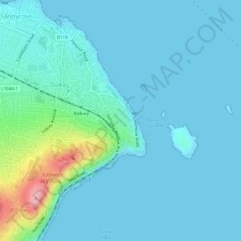
Nom : Carte topographique Dalkey Commons, altitude, relief.
Altitude moyenne : 19 m
Altitude minimum : 0 m
Altitude maximum : 148 m
Autres cartes topographiques
Cliquez sur une carte pour visualiser sa topographie, son altitude et son relief.
Dalkey-Bullock ED
Dalkey-Bullock ED, Dalkey, Dún Laoghaire-Rathdown, County Dublin, Leinster, SW17 7EG, Ireland
Altitude moyenne : 22 m
Dalkey Island
Dalkey Island, Shankill-Rathsallagh ED, Dalkey, Dún Laoghaire-Rathdown, County Dublin, Leinster, Ireland
Altitude moyenne : 6 m