
Carte topographique Broken Bow
Carte interactive
Cliquez sur la carte pour afficher l’altitude.
À propos de cette carte
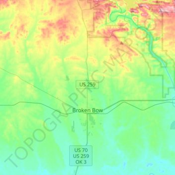
Nom : Carte topographique Broken Bow, altitude, relief.
Lieu : Broken Bow, McCurtain County, Oklahoma, United States (33.95544 -94.77445 34.15653 -94.70551)
Altitude moyenne : 155 m
Altitude minimum : 95 m
Altitude maximum : 304 m
The city sits at the foothills of the Kiamichi Mountains, a subrange of the Ouachita Mountains. the Kiamichi Mountains sit within Le Flore, Pushmataha, and McCurtain counties near the towns of Poteau and Albion. The Kiamichi peaks line up south of the Kiamichi River and reach 2,500 feet (760 m) in elevation. The range is the namesake of Kiamichi Country, the official tourism designation for southeastern Oklahoma.
Autres cartes topographiques
Cliquez sur une carte pour visualiser sa topographie, son altitude et son relief.
Broken Bow Lake
United States > Oklahoma > McCurtain County
Broken Bow Lake, McCurtain County, Oklahoma, United States
Altitude moyenne : 158 m
Candy Mountain
United States > Oklahoma > McCurtain County
Candy Mountain, McCurtain County, Oklahoma, United States
Altitude moyenne : 251 m
Sherwood
United States > Oklahoma > McCurtain County > Sherwood
Sherwood, McCurtain County, Oklahoma, United States
Altitude moyenne : 307 m