
Carte topographique Rio Branco
Carte interactive
Cliquez sur la carte pour afficher l’altitude.
À propos de cette carte
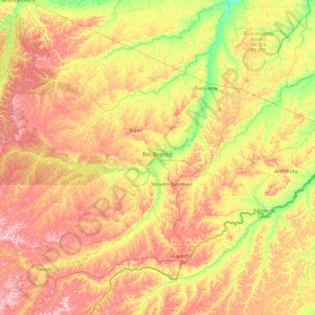
Nom : Carte topographique Rio Branco, altitude, relief.
Altitude moyenne : 176 m
Altitude minimum : 100 m
Altitude maximum : 282 m
Rio Branco is located at 9° 58' 29" south and 67° 48' 36" west, at an altitude of 143 metres (469 ft) above sea level. The city has developed on both sides of the Acre River, with areas known as the First (left bank) and Second Districts. The river is crossed by six bridges, the newest bridge being the Joaquim Macedo Catwalk.
Autres cartes topographiques
Cliquez sur une carte pour visualiser sa topographie, son altitude et son relief.