
Carte topographique Elbląg
Carte interactive
Cliquez sur la carte pour afficher l’altitude.
Elbląg
The modern city adjoins about half the length of the river between Lake Drużno and Elbląg Bay (Zatoka Elbląska, an arm of the Vistula Lagoon), and spreads out on both banks, though mainly on the eastern side. To the east is the Elbląg Upland (Wysoczyzna Elbląska), a dome pushed up by glacial compression, 390 km2 in diameter and 200 m (656.17 ft) high at its greatest elevation. It gives the appearance of ridges and parkland.
À propos de cette carte
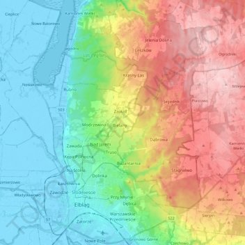
Nom : Carte topographique Elbląg, altitude, relief.
Lieu : Elbląg, Warmian-Masurian Voivodeship, Poland (54.13445 19.35901 54.26326 19.50969)
Altitude moyenne : 75 m
Altitude minimum : -6 m
Altitude maximum : 197 m
Autres cartes topographiques
Cliquez sur une carte pour visualiser sa topographie, son altitude et son relief.
Masurian Lake District
Poland > Warmian-Masurian Voivodeship > Mrągowo County
Altitude moyenne : 110 m
Rodowo
Poland > Warmian-Masurian Voivodeship > Mrągowo County > Jędrychowo > Rodowo
Altitude moyenne : 162 m
Dylewska Góra
Poland > Warmian-Masurian Voivodeship > Ostróda County > Wysoka Wieś
Dylewska Góra (German: Kernsdorfer Höhe) is a hill located in northeastern Poland, south of the town of Ostróda, in the Warmian-Masurian Voivodeship. With elevation of 312 metres above sea level, it is one of the highest points of northern and central Poland. Dylewska Góra is a morainic hill, with its…
Altitude moyenne : 269 m