
Carte topographique Vayots Dzor
Carte interactive
Cliquez sur la carte pour afficher l’altitude.
À propos de cette carte
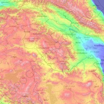
Nom : Carte topographique Vayots Dzor, altitude, relief.
Lieu : Vayots Dzor, Arménie (37.24198 42.89576 42.36198 48.01576)
Altitude moyenne : 1 464 m
Altitude minimum : -30 m
Altitude maximum : 4 746 m
Autres cartes topographiques
Cliquez sur une carte pour visualiser sa topographie, son altitude et son relief.