Géolocaliser

Carte topographique İzmit

Carte interactive

Cliquez sur la carte pour afficher l’altitude.

İzmit

The city is mostly built on hill slopes because of the cramped area, while flat plains surround the gulf, near the sea. This topographic structure divided the city into two parts. The first was created on flat plains, where the city center is. The railway and highway networks pass from this area which is close to the Sea of Marmara. The second part was built on hills, with many historic houses from the Ottoman period in the old quarters.

Wikipedia (CC-BY-SA 3.0)

À propos de cette carte

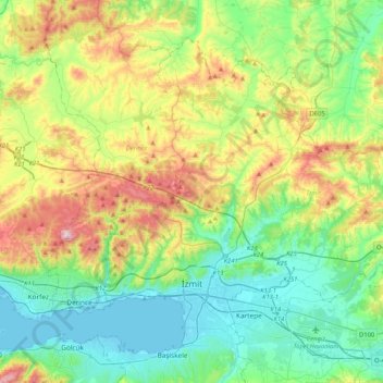
Nom : Carte topographique İzmit, altitude, relief.

Lieu : İzmit, Kocaeli, Marmara Region, Turkey (40.72027 29.85420 40.97193 30.26750)

Altitude moyenne : 194 m

Altitude minimum : -2 m

Altitude maximum : 641 m

Autres cartes topographiques

Cliquez sur une carte pour visualiser sa topographie, son altitude et son relief.

Istanbul

Turkey > Fatih

Istanbul, located in northwestern Turkey, is a city that is uniquely situated across two continents, Europe and Asia, divided by the Bosphorus Strait. The city’s topography is characterized by a complex blend of hills, valleys, and coastal plains, which create a varied and scenic landscape. The European side…

Altitude moyenne : 57 m

Antalya

Turkey > Muratpaşa

While the city itself only has modest elevation changes, Antalya has high mountains in all directions to its interior. With moisture being trapped, the local climate thus has high winter rainfall, while the interior bay setting result in very hot summers for a coastal city.

Altitude moyenne : 117 m

Pınargözü

Turkey > Kangal

Altitude moyenne : 1 605 m

Istanbul

Turkey > Fatih

Istanbul, located in northwestern Turkey, is a city that is uniquely situated across two continents, Europe and Asia, divided by the Bosphorus Strait. The city’s topography is characterized by a complex blend of hills, valleys, and coastal plains, which create a varied and scenic landscape. The European side…

Altitude moyenne : 57 m

Pınargözü

Turkey > Yüksekova

Altitude moyenne : 1 893 m

Bursa

Turkey > Osmangazi

Altitude moyenne : 598 m

Gözlek Yaylası

Turkey > Konyaaltı

Altitude moyenne : 1 734 m

Işıklar

Turkey > Süleymanpaşa

Altitude moyenne : 271 m

Gürçamlar

Turkey > Milas

Altitude moyenne : 145 m

Ankara

Turkey > Ankara > Çankaya

Ankara has a cold semi-arid climate (Köppen climate classification: BSk). Under the Trewartha climate classification, Ankara has a temperate humid continental climate (Dc). Due to its elevation and inland location, Ankara has cold and snowy winters, and hot and dry summers. Rainfall occurs mostly during the…

Altitude moyenne : 1 082 m

İzmir

Turkey > Konak

Altitude moyenne : 263 m

Salur

Turkey > Refahiye

Altitude moyenne : 1 735 m

Aksu

Turkey > Hendek

Altitude moyenne : 701 m

Kopal

Turkey > Karaçoban

Altitude moyenne : 1 737 m

Karacaören

Turkey > Menteşe

Altitude moyenne : 729 m

Işıklar

Turkey > Kızıltepe

Altitude moyenne : 470 m

Istanbul

Turkey > Istanbul > Fatih

Istanbul, located in northwestern Turkey, is a city that is uniquely situated across two continents, Europe and Asia, divided by the Bosphorus Strait. The city’s topography is characterized by a complex blend of hills, valleys, and coastal plains, which create a varied and scenic landscape. The European side…

Altitude moyenne : 57 m

Erikli

Turkey > Kızıltepe

Altitude moyenne : 509 m

Kaleyüzü

Turkey > Feke

Altitude moyenne : 1 218 m

Çakmak

Turkey > Menteşe

Altitude moyenne : 871 m

İl

Turkey > Başkale > Keçilioba

Altitude moyenne : 2 338 m

Yeniyapan Şeyhli

Turkey > Ankara > Balâ

Altitude moyenne : 986 m

Yeniyapan Şeyhli

Turkey > Ankara > Balâ

Altitude moyenne : 986 m

Kümbet

Turkey > Yıldızeli

Altitude moyenne : 1 625 m

Sazlı

Turkey > Ayvacık

Altitude moyenne : 258 m

Zekeriyaköy

Turkey > Yapraklı

Altitude moyenne : 1 232 m

Dikilitaş

Turkey > Kozan

Altitude moyenne : 99 m

Kapaklı

Turkey > Daday

Altitude moyenne : 1 095 m

Kızılelma

Turkey > Bartın

Altitude moyenne : 50 m

Karlı

Turkey > Eflani

Altitude moyenne : 1 021 m

Dumanlı

Turkey > Gümüşhane

Altitude moyenne : 1 756 m

Gaziantep

Turkey > Şahinbey

The plan introduced several important changes to the city's transportation network. One of the most important was the addition of a rail line to connect Gaziantep to the national rail system. Up to now, Turkish railway construction had ignored Gaziantep (partly because of its mountainous surroundings); a…

Altitude moyenne : 880 m

Arslanköy

Turkey > Toroslar

Arslanköy is a mountain town situated in the Toros Mountains at an altitude of approximately 1,475 metres (4,839 ft). The distance by road to Mersin is 51 kilometres (32 mi).

Altitude moyenne : 1 534 m

Tahir

Turkey > Eleşkirt

Altitude moyenne : 2 290 m

Hanyatak

Turkey > Akyazı

Altitude moyenne : 872 m

Kayseri

Turkey > Melikgazi

Kayseri sits at the foot of Mount Erciyes (Turkish: Erciyes Dağı), a dormant volcano that reaches an altitude of 3,917 metres (12,851 feet), more than 1,500 metres above the city's mean altitude. It contains a number of historic monuments, particularly from the Seljuk period. Tourists often pass through…

Altitude moyenne : 1 345 m

Döngelli

Turkey > Akçakoca

Altitude moyenne : 58 m

Gökçeovacık

Turkey > Fethiye

Altitude moyenne : 574 m

Zincirlikuyu

Turkey

Altitude moyenne : 963 m

Gökbez

Turkey > Pozantı

Altitude moyenne : 922 m

Karaca

Turkey > Çorum

Altitude moyenne : 757 m

Çenger

Turkey > Fethiye

Altitude moyenne : 671 m

Paşadüzü

Turkey > Ovacık

Altitude moyenne : 1 330 m

Düzoba Yaylası

Turkey > Kumru > Çatılı Mahallesi

Altitude moyenne : 1 551 m

Yolboyu

Turkey > Pazarcık

Altitude moyenne : 730 m

Muğla

Turkey > Menteşe

Muğla (Turkish: [ˈmuːɫa]) is a city in southwestern Turkey. The city is the center of the district of Menteşe and Muğla Province, which stretches along Turkey's Aegean coast. Muğla's center is situated inland at an altitude of 660 m and lies at a distance of about 30 km (19 mi) from the nearest seacoast…

Altitude moyenne : 841 m

Tatar

Turkey > Suşehri

Altitude moyenne : 1 605 m

Ortayol

Turkey > Başkale

Altitude moyenne : 2 236 m

Mursallı

Turkey > Şarköy

Altitude moyenne : 346 m

Heybeli

Turkey > Erzincan

Altitude moyenne : 1 528 m

Şenocak

Turkey > Haliliye

Altitude moyenne : 467 m

Taurus Mountains

Turkey

The mountains have a Mediterranean climate, with dry summers and rainy winters. Temperatures vary with elevation, with warm winters on the lower coastal slopes and cold winters in the high mountains and in the interior.

Altitude moyenne : 828 m

Tepe

Turkey > Lice

Altitude moyenne : 818 m

Konya

Turkey > Selçuklu

Altitude moyenne : 1 160 m

Kozlu

Turkey > Bolu

Altitude moyenne : 1 283 m

Beşyol

Turkey > Besni

Altitude moyenne : 542 m

Bıyıklıalanı

Turkey > Keles

Altitude moyenne : 1 029 m

Madas

Turkey > Tokat

Altitude moyenne : 1 211 m

Akçakese

Turkey > Boyabat

Altitude moyenne : 1 078 m

Develik

Turkey > Ahlat

Altitude moyenne : 2 126 m

Uludoruk Dağı

Turkey > Yüksekova

Altitude moyenne : 3 363 m

Aşağı Tavla

Turkey > Doğubayazıt

Altitude moyenne : 1 518 m

Tatköy

Turkey > Selçuklu

Altitude moyenne : 1 525 m

İbrahimli

Turkey > Kastamonu

Altitude moyenne : 1 244 m

İslamköy

Turkey > Kulp

Altitude moyenne : 1 282 m

Akdam

Turkey > Alanya

Altitude moyenne : 131 m

Tat

Turkey > Korkuteli

Altitude moyenne : 998 m

Göbekli Tepe

Turkey > Haliliye > Örencik Mahallesi

Altitude moyenne : 702 m

Kızılsu

Turkey > Şırnak

Altitude moyenne : 908 m

Arak

Turkey > Mengen

Altitude moyenne : 871 m

İslamköy

Turkey > Kulp

Altitude moyenne : 1 282 m

Akköy

Turkey > Bismil

Altitude moyenne : 626 m

Durupınar

Turkey > Elazığ

Altitude moyenne : 1 188 m

Bucakdere

Turkey > Sütçüler

Altitude moyenne : 1 305 m

Çanakçılar

Turkey > Bolu

Altitude moyenne : 864 m

Kocaoğlanlı

Turkey > Alanya

Altitude moyenne : 272 m

Çandır

Turkey > Köyceğiz

Altitude moyenne : 135 m

Kazıklı

Turkey > Şahinbey

Altitude moyenne : 645 m

Batıköy

Turkey > Didim

Altitude moyenne : 7 m

Yenikent

Turkey > Aksaray

Altitude moyenne : 921 m

Ümit

Turkey > Kastamonu

Altitude moyenne : 1 049 m

Trabzon

Turkey > Trabzon > Ortahisar

Altitude moyenne : 241 m

Kartalkaya Kayak Merkezi

Turkey > Seben > Gerenözü Köyü

Altitude moyenne : 2 003 m

Çandır

Turkey > Milas

Altitude moyenne : 176 m

Çıralı

Turkey > Yusufeli

Altitude moyenne : 1 330 m

Çandır

Turkey > Çivril

Altitude moyenne : 823 m

Bostanlı

Turkey > Kâhta

Altitude moyenne : 572 m

Akçakent

Turkey > Nizip

Altitude moyenne : 552 m

Altaş

Turkey > Ardahan

Altitude moyenne : 1 810 m

Vagon Park

Turkey > Sakarya > Adapazarı

Altitude moyenne : 52 m

Istanbul

Turkey > Istanbul > Fatih

Altitude moyenne : 57 m

Kiriş

Turkey > Kemer

Altitude moyenne : 44 m

Istanbul

Turkey > Fatih

Istanbul, located in northwestern Turkey, is a city that is uniquely situated across two continents, Europe and Asia, divided by the Bosphorus Strait. The city’s topography is characterized by a complex blend of hills, valleys, and coastal plains, which create a varied and scenic landscape. The European side…

Altitude moyenne : 57 m

Çokal Dam

Turkey > Gelibolu > Çokal

Altitude moyenne : 97 m

Murat Dağı

Turkey > Gediz

Altitude moyenne : 2 105 m

Uludağ

Turkey > Osmangazi

Uludağ (Turkish pronunciation: [ˈuɫudaː]), the ancient Mysian or Bithynian Olympus (Greek: Όλυμπος), is a mountain in Bursa Province, Turkey, with an elevation of 2,543 m (8,343 ft).

Altitude moyenne : 2 265 m

Garipce

Turkey > Korkuteli

Altitude moyenne : 856 m

Sarıcaeli

Turkey > Çanakkale Merkez

Altitude moyenne : 119 m

Erzurum

Turkey > Yakutiye

Altitude moyenne : 2 089 m

Kösedağ

Turkey > Suşehri

Altitude moyenne : 2 088 m