
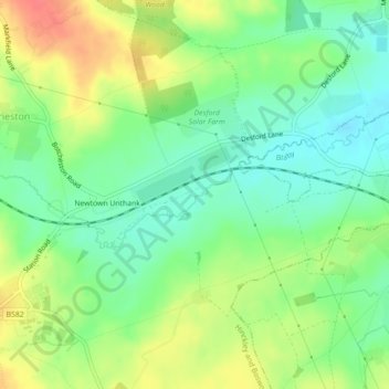
Carte topographique Rothley Brook
Carte interactive
Cliquez sur la carte pour afficher l’altitude.
À propos de cette carte
Nom : Carte topographique Rothley Brook, altitude, relief.
Altitude moyenne : 99 m
Altitude minimum : 75 m
Altitude maximum : 133 m
Autres cartes topographiques
Cliquez sur une carte pour visualiser sa topographie, son altitude et son relief.
Ratby
United Kingdom > England > Hinckley and Bosworth
Ratby, Hinckley and Bosworth, Leicestershire, East Midlands, England, United Kingdom
Altitude moyenne : 118 m
Barwell
United Kingdom > England > Hinckley and Bosworth > Barwell
Barwell, Hinckley and Bosworth, Leicestershire, East Midlands, England, LE9 8DD, United Kingdom
Altitude moyenne : 111 m
Bagworth & Thornton
United Kingdom > England > Hinckley and Bosworth
Bagworth & Thornton, Hinckley and Bosworth, Leicestershire, East Midlands, England, United Kingdom
Altitude moyenne : 140 m
Peckleton
United Kingdom > England > Hinckley and Bosworth
Peckleton, Hinckley and Bosworth, Leicestershire, East Midlands, England, United Kingdom
Altitude moyenne : 113 m
Tweed River
United Kingdom > England > Hinckley and Bosworth
Tweed River, Hinckley and Bosworth, Leicestershire, East Midlands, England, CV13 6DS, United Kingdom
Altitude moyenne : 98 m