
Faire un don
Équipez-vous pour votre prochaine aventure :
En tant que Partenaire Amazon, ce site perçoit une commission sur les achats éligibles sans surcoût pour vous.
Carte topographique Monterosso al Mare
Cliquez sur la carte pour afficher l’altitude.
Faire un don
Équipez-vous pour votre prochaine aventure :
En tant que Partenaire Amazon, ce site perçoit une commission sur les achats éligibles sans surcoût pour vous.
À propos de cette carte
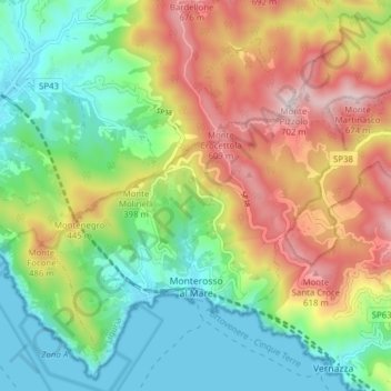
Nom : Carte topographique Monterosso al Mare, altitude, relief.
Lieu : Monterosso al Mare, La Spezia, Liguria, Italy (44.13349 9.62439 44.18547 9.70193)
Altitude moyenne : 266 m
Altitude minimum : 0 m
Altitude maximum : 686 m
Faire un don
Équipez-vous pour votre prochaine aventure :
En tant que Partenaire Amazon, ce site perçoit une commission sur les achats éligibles sans surcoût pour vous.
Autres cartes topographiques
Cliquez sur une carte pour visualiser sa topographie, son altitude et son relief.
Faire un don
Équipez-vous pour votre prochaine aventure :
En tant que Partenaire Amazon, ce site perçoit une commission sur les achats éligibles sans surcoût pour vous.
Faire un don
Équipez-vous pour votre prochaine aventure :
En tant que Partenaire Amazon, ce site perçoit une commission sur les achats éligibles sans surcoût pour vous.
Faire un don
Équipez-vous pour votre prochaine aventure :
En tant que Partenaire Amazon, ce site perçoit une commission sur les achats éligibles sans surcoût pour vous.
Faire un don
Équipez-vous pour votre prochaine aventure :
En tant que Partenaire Amazon, ce site perçoit une commission sur les achats éligibles sans surcoût pour vous.
La Spezia
Because of its topography, the city is not exposed to winds from the north, which lap western Liguria, but to those from the southeast. These may bring heavy rain and they can reach 80 kilometres per hour (50 mph), in rare cases causing the blocking of the port. The only northern wind reaching the city is the…
Altitude moyenne : 35 m