
Faire un don
Équipez-vous pour votre prochaine aventure :
En tant que Partenaire Amazon, ce site perçoit une commission sur les achats éligibles sans surcoût pour vous.
Carte topographique okres Svitavy
Cliquez sur la carte pour afficher l’altitude.
Faire un don
Équipez-vous pour votre prochaine aventure :
En tant que Partenaire Amazon, ce site perçoit une commission sur les achats éligibles sans surcoût pour vous.
okres Svitavy
The terrain is undulating to hilly. The territory extends into five geomorphological mesoregions: Svitavy Uplands (most of the territory), Upper Svratka Highlands (southwest), Orlické Foothills (a strip from northeast to southeast), Zábřeh Highlands (east) and Boskovice Furrow (a small part in the southeast). The highest point of the district is the hill Bubnovaný kopec in Pustá Rybná with an elevation of 780 m (2,560 ft), the lowest point is the river bed of the Loučná in Cerekvice nad Loučnou at 278 m (912 ft).
Faire un don
Équipez-vous pour votre prochaine aventure :
En tant que Partenaire Amazon, ce site perçoit une commission sur les achats éligibles sans surcoût pour vous.
À propos de cette carte
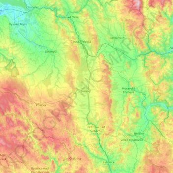
Nom : Carte topographique okres Svitavy, altitude, relief.
Lieu : okres Svitavy, Pardubice Region, Northeast, Czechia (49.57213 16.06261 49.96509 16.84851)
Altitude moyenne : 488 m
Altitude minimum : 249 m
Altitude maximum : 953 m
Faire un don
Équipez-vous pour votre prochaine aventure :
En tant que Partenaire Amazon, ce site perçoit une commission sur les achats éligibles sans surcoût pour vous.
Autres cartes topographiques
Cliquez sur une carte pour visualiser sa topographie, son altitude et son relief.
Morava
Czechia > Northeast > Pardubice Region > Dolní Morava
The Morava originates in the territory of Dolní Morava in the Králický Sněžník Mountains, on the slope of the Králický Sněžník mountain at an elevation of 1,371 m (4,498 ft), not far from the border with Poland. The lowlands formed by the river are the Upper Morava Valley and then the Lower Morava…
Altitude moyenne : 1 172 m
Králický Sněžník / Śnieżnik
Czechia > Northeast > Pardubice Region > Dolní Morava
Altitude moyenne : 1 173 m
Faire un don
Équipez-vous pour votre prochaine aventure :
En tant que Partenaire Amazon, ce site perçoit une commission sur les achats éligibles sans surcoût pour vous.