
Carte topographique Lac Chalain
Carte interactive
Cliquez sur la carte pour afficher l’altitude.
À propos de cette carte
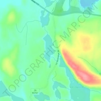
Nom : Carte topographique Lac Chalain, altitude, relief.
Altitude moyenne : 384 m
Altitude minimum : 353 m
Altitude maximum : 449 m
Autres cartes topographiques
Cliquez sur une carte pour visualiser sa topographie, son altitude et son relief.
Lac Cellier
Canada > Québec > La Vallée-de-la-Gatineau > Lac-Pythonga
Lac Cellier, Lac-Pythonga, La Vallée-de-la-Gatineau, Outaouais, Québec, Canada
Altitude moyenne : 375 m
Lac Grey
Canada > Québec > La Vallée-de-la-Gatineau > Lac-Pythonga
Lac Grey, Lac-Pythonga, La Vallée-de-la-Gatineau, Outaouais, Québec, Canada
Altitude moyenne : 387 m
Lac Bow
Canada > Québec > La Vallée-de-la-Gatineau > Lac-Pythonga
Lac Bow, Lac-Pythonga, La Vallée-de-la-Gatineau, Outaouais, Québec, Canada
Altitude moyenne : 389 m
Lac Tarse
Canada > Québec > La Vallée-de-la-Gatineau > Lac-Pythonga
Lac Tarse, Lac-Pythonga, La Vallée-de-la-Gatineau, Outaouais, Québec, Canada
Altitude moyenne : 279 m