
Carte topographique Gregory County
Carte interactive
Cliquez sur la carte pour afficher l’altitude.
À propos de cette carte
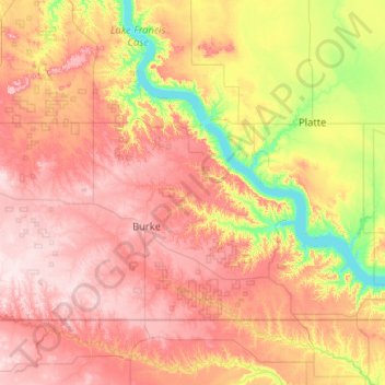
Nom : Carte topographique Gregory County, altitude, relief.
Lieu : Gregory County, South Dakota, United States (42.99797 -99.53409 43.49973 -98.49855)
Altitude moyenne : 564 m
Altitude minimum : 408 m
Altitude maximum : 729 m
Autres cartes topographiques
Cliquez sur une carte pour visualiser sa topographie, son altitude et son relief.
Sioux Falls
United States > South Dakota > Minnehaha County
Sioux Falls, Sioux Falls Township, Minnehaha County, South Dakota, United States
Altitude moyenne : 445 m
Rapid City
United States > South Dakota > Pennington County
Rapid City, Pennington County, South Dakota, United States
Altitude moyenne : 1 067 m
Springdale Township
United States > South Dakota > Lincoln County
Springdale Township, Lincoln County, South Dakota, United States
Altitude moyenne : 432 m
Aberdeen
United States > South Dakota > Brown County
Aberdeen, Brown County, South Dakota, 57401, United States
Altitude moyenne : 399 m
White Rock
United States > South Dakota > Roberts County
White Rock, Roberts County, South Dakota, United States
Altitude moyenne : 300 m
Redfield
United States > South Dakota > Spink County
Redfield, Redfield Township, Spink County, South Dakota, United States
Altitude moyenne : 396 m
Pierre
United States > South Dakota > Hughes County
Pierre, Hughes County, South Dakota, 57501, United States
Altitude moyenne : 469 m
Black Hills
United States > South Dakota > Pennington County
Black Hills, Pennington County, South Dakota, United States
Altitude moyenne : 1 894 m
Yankton
United States > South Dakota > Yankton County
Yankton, Mission Hill South Township, Yankton County, South Dakota, United States
Altitude moyenne : 380 m
Hermosa
United States > South Dakota > Custer County
Hermosa, Custer County, South Dakota, United States
Altitude moyenne : 1 010 m
Blunt
United States > South Dakota > Hughes County
Blunt, Hughes County, South Dakota, United States
Altitude moyenne : 504 m
Perkins County
Perkins County, South Dakota, United States
Altitude moyenne : 799 m
Chamberlain
United States > South Dakota > Brule County
Chamberlain, Brule County, South Dakota, 57325, United States
Altitude moyenne : 482 m
Badlands National Park
United States > South Dakota > Oglala Lakota County
Badlands National Park, Oglala Lakota County, South Dakota, 57750, United States
Altitude moyenne : 848 m
Badlands
United States > South Dakota > Perkins County
Badlands, Perkins County, South Dakota, United States
Altitude moyenne : 827 m
Bennett County
Bennett County, South Dakota, United States
Altitude moyenne : 954 m
Charles Mix County
Charles Mix County, South Dakota, United States
Altitude moyenne : 500 m
Bon Homme County
Bon Homme County, South Dakota, United States
Altitude moyenne : 438 m
Aurora County
Aurora County, South Dakota, United States
Altitude moyenne : 479 m
Deuel County
Deuel County, South Dakota, United States
Altitude moyenne : 529 m
Todd County
Todd County, South Dakota, United States
Altitude moyenne : 808 m
Butte County
Butte County, South Dakota, United States
Altitude moyenne : 928 m
Spearfish
United States > South Dakota > Lawrence County > Spearfish
Spearfish, Lawrence County, South Dakota, 57783, United States
Altitude moyenne : 1 291 m
Brookings
United States > South Dakota > Brookings County > Brookings
Brookings, Brookings County, South Dakota, 57007, United States
Altitude moyenne : 509 m
Agar
United States > South Dakota > Agar
Agar, Sully County, South Dakota, United States
Altitude moyenne : 569 m
Bad River
Bad River, South Dakota, 57532, United States
Altitude moyenne : 628 m
Brule County
United States > South Dakota > Brule County
Brule County, South Dakota, United States
Altitude moyenne : 505 m
Spearfish
United States > South Dakota > Lawrence County
Spearfish, Lawrence County, South Dakota, United States
Altitude moyenne : 1 171 m
Brookings County
Brookings County, South Dakota, United States
Altitude moyenne : 525 m
Lyman County
Lyman County, South Dakota, United States
Altitude moyenne : 539 m
Baltic
United States > South Dakota > Minnehaha County
Baltic, Sverdup Township, Minnehaha County, South Dakota, United States
Altitude moyenne : 454 m
Lead
United States > South Dakota > Lead > Lead
Lead, Lawrence County, South Dakota, United States
Altitude moyenne : 1 605 m
Pennington County
Pennington County, South Dakota, United States
Altitude moyenne : 960 m
Elk Point
United States > South Dakota > Union County
Elk Point, Elk Point East Township, Union County, South Dakota, United States
Altitude moyenne : 343 m
Minnehaha County
Minnehaha County, South Dakota, United States
Altitude moyenne : 469 m
Freeman
United States > South Dakota > Hutchinson County
Freeman, Hutchinson County, South Dakota, 57029, United States
Altitude moyenne : 465 m
Oacoma
United States > South Dakota > Lyman County
Oacoma, Lyman County, South Dakota, 57365, United States
Altitude moyenne : 452 m