
Carte topographique Deuel County
Carte interactive
Cliquez sur la carte pour afficher l’altitude.
À propos de cette carte
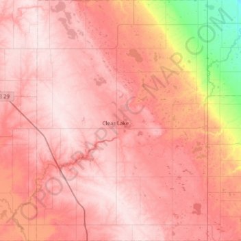
Nom : Carte topographique Deuel County, altitude, relief.
Lieu : Deuel County, South Dakota, United States (44.54365 -96.88553 44.97765 -96.45123)
Altitude moyenne : 529 m
Altitude minimum : 334 m
Altitude maximum : 621 m
Deuel County lies on the east boundary line of South Dakota. Its east boundary line abuts the west boundary line of the state of Minnesota. Its terrain consists of rolling hills, sloped to the northeast. The area is largely devoted to agriculture. The county's highest elevation occurs on its upper west boundary line, at 1,936' (590m) ASL. The county has a total area of 637 square miles (1,650 km2), of which 623 square miles (1,610 km2) is land and 14 square miles (36 km2) (2.2%) is water.
Autres cartes topographiques
Cliquez sur une carte pour visualiser sa topographie, son altitude et son relief.
Rapid City
United States > South Dakota > Pennington County
Rapid City, Pennington County, South Dakota, United States
Altitude moyenne : 1 067 m
Sioux Falls
United States > South Dakota > Minnehaha County
Sioux Falls, Sioux Falls Township, Minnehaha County, South Dakota, United States
Altitude moyenne : 445 m
Springdale Township
United States > South Dakota > Lincoln County
Springdale Township, Lincoln County, South Dakota, United States
Altitude moyenne : 432 m
Aberdeen
United States > South Dakota > Brown County
Aberdeen, Brown County, South Dakota, 57401, United States
Altitude moyenne : 399 m
White Rock
United States > South Dakota > Roberts County
White Rock, Roberts County, South Dakota, United States
Altitude moyenne : 300 m
Redfield
United States > South Dakota > Spink County
Redfield, Redfield Township, Spink County, South Dakota, United States
Altitude moyenne : 396 m
Pierre
United States > South Dakota > Hughes County
Pierre, Hughes County, South Dakota, 57501, United States
Altitude moyenne : 469 m
Black Hills
United States > South Dakota > Pennington County
Black Hills, Pennington County, South Dakota, United States
Altitude moyenne : 1 894 m
Yankton
United States > South Dakota > Yankton County
Yankton, Mission Hill South Township, Yankton County, South Dakota, United States
Altitude moyenne : 380 m
Gregory County
Gregory County, South Dakota, United States
Altitude moyenne : 564 m
Hermosa
United States > South Dakota > Custer County
Hermosa, Custer County, South Dakota, United States
Altitude moyenne : 1 010 m
Blunt
United States > South Dakota > Hughes County
Blunt, Hughes County, South Dakota, United States
Altitude moyenne : 504 m
Perkins County
Perkins County, South Dakota, United States
Altitude moyenne : 799 m
Chamberlain
United States > South Dakota > Brule County
Chamberlain, Brule County, South Dakota, 57325, United States
Altitude moyenne : 482 m
Badlands National Park
United States > South Dakota > Oglala Lakota County
Badlands National Park, Oglala Lakota County, South Dakota, 57750, United States
Altitude moyenne : 848 m
Badlands
United States > South Dakota > Perkins County
Badlands, Perkins County, South Dakota, United States
Altitude moyenne : 827 m
Bennett County
Bennett County, South Dakota, United States
Altitude moyenne : 954 m
Charles Mix County
Charles Mix County, South Dakota, United States
Altitude moyenne : 500 m
Bon Homme County
Bon Homme County, South Dakota, United States
Altitude moyenne : 438 m
Aurora County
Aurora County, South Dakota, United States
Altitude moyenne : 479 m
Todd County
Todd County, South Dakota, United States
Altitude moyenne : 808 m
Butte County
Butte County, South Dakota, United States
Altitude moyenne : 928 m
Spearfish
United States > South Dakota > Lawrence County > Spearfish
Spearfish, Lawrence County, South Dakota, 57783, United States
Altitude moyenne : 1 291 m
Brookings
United States > South Dakota > Brookings County > Brookings
Brookings, Brookings County, South Dakota, 57007, United States
Altitude moyenne : 509 m
Agar
United States > South Dakota > Agar
Agar, Sully County, South Dakota, United States
Altitude moyenne : 569 m
Bad River
Bad River, South Dakota, 57532, United States
Altitude moyenne : 628 m
Brule County
United States > South Dakota > Brule County
Brule County, South Dakota, United States
Altitude moyenne : 505 m
Spearfish
United States > South Dakota > Lawrence County
Spearfish, Lawrence County, South Dakota, United States
Altitude moyenne : 1 171 m
Brookings County
Brookings County, South Dakota, United States
Altitude moyenne : 525 m
Lyman County
Lyman County, South Dakota, United States
Altitude moyenne : 539 m
Baltic
United States > South Dakota > Minnehaha County
Baltic, Sverdup Township, Minnehaha County, South Dakota, United States
Altitude moyenne : 454 m
Lead
United States > South Dakota > Lead > Lead
Lead, Lawrence County, South Dakota, United States
Altitude moyenne : 1 605 m
Pennington County
Pennington County, South Dakota, United States
Altitude moyenne : 960 m
Elk Point
United States > South Dakota > Union County
Elk Point, Elk Point East Township, Union County, South Dakota, United States
Altitude moyenne : 343 m
Minnehaha County
Minnehaha County, South Dakota, United States
Altitude moyenne : 469 m
Freeman
United States > South Dakota > Hutchinson County
Freeman, Hutchinson County, South Dakota, 57029, United States
Altitude moyenne : 465 m
Oacoma
United States > South Dakota > Lyman County
Oacoma, Lyman County, South Dakota, 57365, United States
Altitude moyenne : 452 m