
Carte topographique Kreuth
Carte interactive
Cliquez sur la carte pour afficher l’altitude.
À propos de cette carte
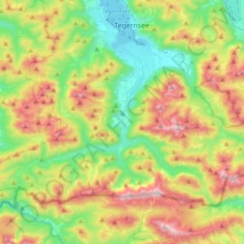
Nom : Carte topographique Kreuth, altitude, relief.
Lieu : Kreuth, Landkreis Miesbach, Bavaria, 83708, Germany (47.58121 11.59798 47.70095 11.85496)
Altitude moyenne : 1 137 m
Altitude minimum : 722 m
Altitude maximum : 1 823 m
Autres cartes topographiques
Cliquez sur une carte pour visualiser sa topographie, son altitude et son relief.
Buch
Germany > Bavaria > Landkreis Miesbach > Bad Wiessee
Buch, Bad Wiessee, Landkreis Miesbach, Bavaria, 83707, Germany
Altitude moyenne : 904 m
Miesbach
Germany > Bavaria > Landkreis Miesbach
Miesbach, Landkreis Miesbach, Bavaria, 83714, Germany
Altitude moyenne : 739 m
Schliersee
Germany > Bavaria > Landkreis Miesbach
Schliersee, Landkreis Miesbach, Bavaria, 83727, Germany
Altitude moyenne : 1 079 m
Floiger
Germany > Bavaria > Landkreis Miesbach > Miesbach
Floiger, Miesbach, Landkreis Miesbach, Bavaria, 83714, Germany
Altitude moyenne : 769 m
Kalten
Germany > Bavaria > Landkreis Miesbach > Niklasreuth
Kalten, Niklasreuth, Irschenberg, Landkreis Miesbach, Bavaria, 83737, Germany
Altitude moyenne : 682 m
Rottach-Egern
Germany > Bavaria > Landkreis Miesbach
Rottach-Egern, Landkreis Miesbach, Bavaria, 83700, Germany
Altitude moyenne : 1 086 m
Tegernsee
Germany > Bavaria > Landkreis Miesbach
Tegernsee, Landkreis Miesbach, Bavaria, 83684, Germany
Altitude moyenne : 858 m
Hausham
Germany > Bavaria > Landkreis Miesbach > Hausham
Hausham, Landkreis Miesbach, Bavaria, 83734, Germany
Altitude moyenne : 854 m