
Carte topographique Phan Dung
Carte interactive
Cliquez sur la carte pour afficher l’altitude.
À propos de cette carte
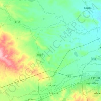
Nom : Carte topographique Phan Dung, altitude, relief.
Lieu : Phan Dung, Nakhon Ratchasima Province, Thailand (14.90208 101.78942 15.22208 102.10942)
Altitude moyenne : 202 m
Altitude minimum : 169 m
Altitude maximum : 304 m
Autres cartes topographiques
Cliquez sur une carte pour visualiser sa topographie, son altitude et son relief.
Ban Som
Thailand > Nakhon Ratchasima Province > Ban Som
Ban Som, Nakhon Ratchasima Province, Thailand
Altitude moyenne : 159 m
Nakhon Ratchasima
Thailand > Nakhon Ratchasima Province
Nakhon Ratchasima, Hua Thale, Nakhon Ratchasima Province, 30000, Thailand
Altitude moyenne : 195 m