
Carte topographique Nakhon Ratchasima
Carte interactive
Cliquez sur la carte pour afficher l’altitude.
À propos de cette carte
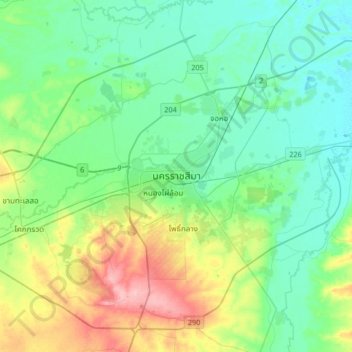
Nom : Carte topographique Nakhon Ratchasima, altitude, relief.
Altitude moyenne : 195 m
Altitude minimum : 164 m
Altitude maximum : 284 m
Autres cartes topographiques
Cliquez sur une carte pour visualiser sa topographie, son altitude et son relief.
Phan Dung
Thailand > Nakhon Ratchasima Province
Phan Dung, Nakhon Ratchasima Province, Thailand
Altitude moyenne : 202 m
Ban Som
Thailand > Nakhon Ratchasima Province > Ban Som
Ban Som, Nakhon Ratchasima Province, Thailand
Altitude moyenne : 159 m