
Carte topographique South Salmara-Mankachar
Carte interactive
Cliquez sur la carte pour afficher l’altitude.
À propos de cette carte
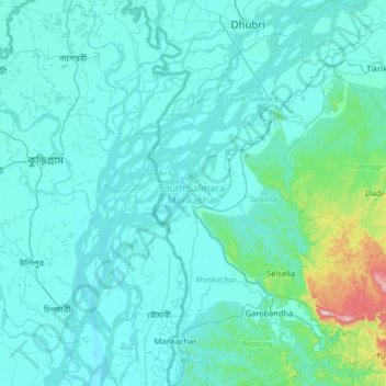
Nom : Carte topographique South Salmara-Mankachar, altitude, relief.
Lieu : South Salmara-Mankachar, Assam, India (25.46652 89.81696 26.05455 90.19636)
Altitude moyenne : 58 m
Altitude minimum : 13 m
Altitude maximum : 639 m
South Salmara Mankachar district occupies an area of 568 square kilometres (219 sq mi). It occupies 980/km 2 (2,500/sq mi) of density and is an administrative district in the state of Assam in India. The district headquarters are located at Hatsingimari town which is situated at about 245 km from Guwahati, the state capital. Earlier it was a sub-division of Dhubri District. It shares its borders with Bangladesh in the west and Meghalaya in the south-east.The general topography of South Salmara Mankachar district is plain with patches of small hillocks like Bansali, Rangatari, etc. All these are situated in the southwestern part of the district. Mighty river Brahmaputra is flowing through this district from east to west with its tributaries, and the majority of the population live on chars in the river. Other rivers are Jinjiram, Kalonadi (also known as Ganol) etc. The average annual rainfall of the district is 2,916 mm (114.8 in).
Autres cartes topographiques
Cliquez sur une carte pour visualiser sa topographie, son altitude et son relief.
Kaziranga National Park and Tiger Reserve
Kaziranga National Park and Tiger Reserve, Bokakhat, Golaghat District, Assam, India
Altitude moyenne : 202 m
North Lakhimpur
North Lakhimpur, Lakhimpur, Assam, India
Altitude moyenne : 96 m
Numaligarh
India > Assam > Bokakhat > Numaligarh
Numaligarh, Bokakhat, Golaghat, Assam, 785615, India
Altitude moyenne : 87 m
Mahatma Gandhi Park
Mahatma Gandhi Park, Chowk Bazar, Atila Gaon, Jorhat, Assam, India
Altitude moyenne : 92 m