
Carte topographique Nagaon
Carte interactive
Cliquez sur la carte pour afficher l’altitude.
À propos de cette carte
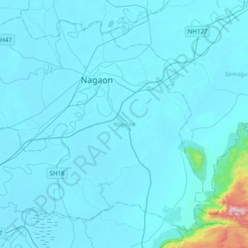
Nom : Carte topographique Nagaon, altitude, relief.
Lieu : Nagaon, Assam, India (26.19742 92.52885 26.41044 92.80400)
Altitude moyenne : 90 m
Altitude minimum : 55 m
Altitude maximum : 846 m
Autres cartes topographiques
Cliquez sur une carte pour visualiser sa topographie, son altitude et son relief.
Kaziranga National Park and Tiger Reserve
Kaziranga National Park and Tiger Reserve, Bokakhat, Golaghat District, Assam, India
Altitude moyenne : 202 m
North Lakhimpur
North Lakhimpur, Lakhimpur, Assam, India
Altitude moyenne : 96 m
Numaligarh
India > Assam > Bokakhat > Numaligarh
Numaligarh, Bokakhat, Golaghat, Assam, 785615, India
Altitude moyenne : 87 m
Mahatma Gandhi Park
Mahatma Gandhi Park, Chowk Bazar, Atila Gaon, Jorhat, Assam, India
Altitude moyenne : 92 m