
Carte topographique Mount Sumner
Carte interactive
Cliquez sur la carte pour afficher l’altitude.
À propos de cette carte
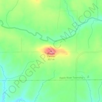
Nom : Carte topographique Mount Sumner, altitude, relief.
Lieu : Mount Sumner, Jo Daviess County, Illinois, 61001, USA (42.46718 -90.14240 42.46728 -90.14230)
Altitude moyenne : 294 m
Altitude minimum : 259 m
Altitude maximum : 354 m
Autres cartes topographiques
Cliquez sur une carte pour visualiser sa topographie, son altitude et son relief.
Fairview Heights
USA > Illinois > Fairview Heights
Fairview Heights, Saint Clair County, Illinois, 62208, USA
Altitude moyenne : 173 m
Hidden Lake
USA > Illinois > Hidden Lake
Hidden Lake, Cook County, Illinois, 60074, USA
Altitude moyenne : 225 m
Lake Marian
USA > Illinois > Carpentersville
Lake Marian, Carpentersville, Kane County, Illinois, 60110, USA
Altitude moyenne : 246 m
Montague Island
Montague Island, Rockford, Winnebago County, Illinois, 61104, USA
Altitude moyenne : 254 m
Lake Carina
Lake Carina, Milwaukee Avenue, Gurnee, Lake County, Illinois, 60031:60085, USA
Altitude moyenne : 213 m
Lake Catherine
USA > Illinois > Lake Catherine
Lake Catherine, Lake County, Illinois, 60002, USA
Altitude moyenne : 229 m
Mount Carmel
USA > Illinois > Mount Carmel
Mount Carmel, Wabash County, Illinois, USA
Altitude moyenne : 128 m