
Carte topographique Uxpanapa
Carte interactive
Cliquez sur la carte pour afficher l’altitude.
À propos de cette carte
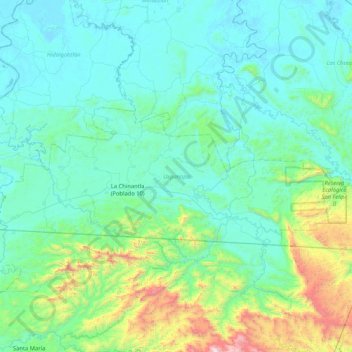
Nom : Carte topographique Uxpanapa, altitude, relief.
Lieu : Uxpanapa, Veracruz, México (17.14943 -94.75924 17.46291 -93.92312)
Altitude moyenne : 259 m
Altitude minimum : 1 m
Altitude maximum : 1 848 m
Autres cartes topographiques
Cliquez sur une carte pour visualiser sa topographie, son altitude et son relief.
Benito Juárez Segundo (La Raya)
Benito Juárez Segundo (La Raya), Uxpanapa, Veracruz, México
Altitude moyenne : 87 m
Poblado Cinco
Poblado Cinco, Uxpanapa, Veracruz, México
Altitude moyenne : 97 m
La Chinantla
La Chinantla, Uxpanapa, Veracruz, México
Altitude moyenne : 117 m
Isthmus of Tehuantepec
Isthmus of Tehuantepec, Uxpanapa, Veracruz, México
Altitude moyenne : 277 m