
Carte topographique Eisenach
Carte interactive
Cliquez sur la carte pour afficher l’altitude.
À propos de cette carte
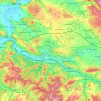
Nom : Carte topographique Eisenach, altitude, relief.
Lieu : Eisenach, Wartburgkreis, Thuringia, 99817, Germany (50.93081 10.17524 51.05239 10.39152)
Altitude moyenne : 298 m
Altitude minimum : 190 m
Altitude maximum : 468 m
Eisenach is situated at the northern edge of the Thuringian Forest, at an elevation of about 220 m. The terrain is hilly, to the south also mountainous (up to 460 m of elevation), with the central Hörsel valley crossing the town in east-western direction. The Nesse river enters the Hörsel river in Eisenach after forming a valley through the spur of the Hörselberg mountains in the eastern municipal territory. The northern territory around the Neunkirchen, Stregda and Hötzelsroda districts is relatively flat and in agricultural use. Approximately 7 km (4 mi) west of the town centre runs the wide Werra valley, where the Hörsel river enters this bigger river near Hörschel district. The southern municipal territory is covered with forest, same as some smaller parts north of the Hörsel river. The Hainich mountains begin 10 km (6 mi) north-east of Eisenach.
Autres cartes topographiques
Cliquez sur une carte pour visualiser sa topographie, son altitude et son relief.
Geisa
Germany > Thuringia > Wartburgkreis > Geisa
Geisa, Wartburgkreis, Thuringia, 36419, Germany
Altitude moyenne : 332 m
Ramsberg
Germany > Thuringia > Wartburgkreis > Lauterbach
Ramsberg, Lauterbach, Hainich-Werratal, Wartburgkreis, Thuringia, 99826, Germany
Altitude moyenne : 324 m
Bad Salzungen
Germany > Thuringia > Wartburgkreis
Bad Salzungen, Wartburgkreis, Thuringia, Germany
Altitude moyenne : 347 m
Gerstungen
Germany > Thuringia > Wartburgkreis
Gerstungen, Wartburgkreis, Thuringia, 99834, Germany
Altitude moyenne : 302 m
Bad Liebenstein
Germany > Thuringia > Wartburgkreis
Bad Liebenstein, Wartburgkreis, Thuringia, Germany
Altitude moyenne : 424 m
Walkes
Germany > Thuringia > Wartburgkreis > Geisa
Walkes, Geisa, Wartburgkreis, Thuringia, Germany
Altitude moyenne : 487 m