
Carte topographique Victoria Peak
Carte interactive
Cliquez sur la carte pour afficher l’altitude.
À propos de cette carte
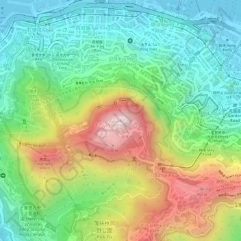
Nom : Carte topographique Victoria Peak, altitude, relief.
Lieu : Victoria Peak, Hong Kong Island, Hong Kong, N/A, China (22.27599 114.14541 22.27609 114.14551)
Altitude moyenne : 209 m
Altitude minimum : -2 m
Altitude maximum : 534 m
Victoria Peak is a hill on the western half of Hong Kong Island. It is also known as Mount Austin, and locally as The Peak. With an elevation of 552 m (1,811 ft), it is the highest hill on Hong Kong island, ranked 31 in terms of elevation in Hong Kong (Tai Mo Shan is the highest point in Hong Kong with an elevation of 957 m (3,140 ft)).
Autres cartes topographiques
Cliquez sur une carte pour visualiser sa topographie, son altitude et son relief.
Ap Lei Chau
China > Hong Kong > Hong Kong Island
Ap Lei Chau, Southern District, Hong Kong Island, Hong Kong, China
Altitude moyenne : 25 m
Mount Davis
China > Hong Kong > Hong Kong Island
Mount Davis, Hong Kong Island, Hong Kong, China
Altitude moyenne : 71 m
Wong Chuk Hang San Wai
China > Hong Kong > Hong Kong Island
Wong Chuk Hang San Wai, Southern District, Hong Kong Island, Hong Kong, China
Altitude moyenne : 116 m
Violet Hill
China > Hong Kong > Hong Kong Island
Violet Hill, Hong Kong Island, Hong Kong, China
Altitude moyenne : 180 m
Hong Kong Island
China > Hong Kong > Hong Kong Island
Hong Kong Island, Wan Chai District, Hong Kong, China
Altitude moyenne : 122 m