
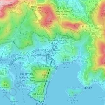
Carte topographique Wong Chuk Hang San Wai
Carte interactive
Cliquez sur la carte pour afficher l’altitude.
À propos de cette carte
Nom : Carte topographique Wong Chuk Hang San Wai, altitude, relief.
Altitude moyenne : 116 m
Altitude minimum : -3 m
Altitude maximum : 468 m
Autres cartes topographiques
Cliquez sur une carte pour visualiser sa topographie, son altitude et son relief.
Ap Lei Chau
China > Hong Kong > Hong Kong Island
Ap Lei Chau, Southern District, Hong Kong Island, Hong Kong, China
Altitude moyenne : 25 m
Mount Davis
China > Hong Kong > Hong Kong Island
Mount Davis, Hong Kong Island, Hong Kong, China
Altitude moyenne : 71 m
Victoria Peak
China > Hong Kong > Hong Kong Island
Victoria Peak, Hong Kong Island, Hong Kong, N/A, China
Altitude moyenne : 209 m
Violet Hill
China > Hong Kong > Hong Kong Island
Violet Hill, Hong Kong Island, Hong Kong, China
Altitude moyenne : 180 m
Hong Kong Island
China > Hong Kong > Hong Kong Island
Hong Kong Island, Wan Chai District, Hong Kong, China
Altitude moyenne : 122 m