
Carte topographique Gangotri Glacier
Carte interactive
Cliquez sur la carte pour afficher l’altitude.
À propos de cette carte
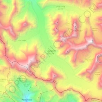
Nom : Carte topographique Gangotri Glacier, altitude, relief.
Lieu : Gangotri Glacier, Bhatwari, Uttarkashi, Uttarakhand, Inde (30.73027 79.07689 30.92663 79.27806)
Altitude moyenne : 5 259 m
Altitude minimum : 3 530 m
Altitude maximum : 7 020 m
Autres cartes topographiques
Cliquez sur une carte pour visualiser sa topographie, son altitude et son relief.
Meru Peak
Inde > Uttarakhand > Bhatwari
Meru Peak, Bhatwari, Uttarkashi district, Uttarakhand, Inde
Altitude moyenne : 5 738 m
Sri Kailas West
Inde > Uttarakhand > Bhatwari
Sri Kailas West, Bhatwari, Uttarkashi district, Uttarakhand, Inde
Altitude moyenne : 6 080 m
Satopanth
Inde > Uttarakhand > Bhatwari
Satopanth, Bhatwari, Uttarkashi district, Uttarakhand, Inde
Altitude moyenne : 6 094 m
Bhaironghati
Inde > Uttarakhand > Bhatwari > Lanka > Bhaironghati
Bhaironghati, Lanka, Bhatwari, Uttarkashi, Uttarakhand, Inde
Altitude moyenne : 3 227 m