Géolocaliser

Carte topographique Satopanth

Cliquez sur la carte pour afficher l’altitude.

À propos de cette carte

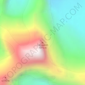
Nom : Carte topographique Satopanth, altitude, relief.

Lieu : Satopanth, Bhatwari, Uttarkashi district, Uttarakhand, Inde (30.84948 79.21429 30.84958 79.21439)

Altitude moyenne : 6 094 m

Altitude minimum : 5 446 m

Altitude maximum : 7 030 m

Autres cartes topographiques

Cliquez sur une carte pour visualiser sa topographie, son altitude et son relief.

Gangnani

Inde > Uttarakhand > Bhatwari

Altitude moyenne : 2 380 m

Gangotri Glacier

Inde > Uttarakhand > Bhatwari

Altitude moyenne : 5 259 m

Équipez-vous pour votre prochaine aventure :

🧤Gants de randonnée - Gants techniques pour protection et confort
🪓Couteaux de randonnée - Couteaux fiables pour usage outdoor
👟Semelles Amortissantes - Confort accru pour les marches sur sols durs ou caillouteux
🏕️Tentes de randonnée - Tentes légères et compactes pour bivouac
📍GPS outdoor - Appareils GPS robustes pour activités outdoor

En tant que Partenaire Amazon, ce site perçoit une commission sur les achats éligibles sans surcoût pour vous.