
Carte topographique Killarney
Carte interactive
Cliquez sur la carte pour afficher l’altitude.
À propos de cette carte
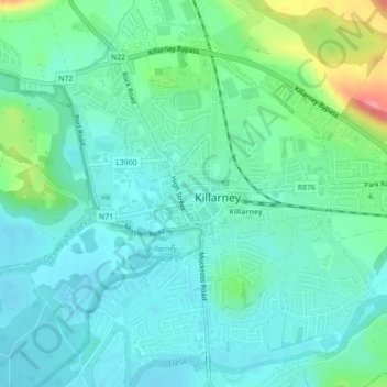
Nom : Carte topographique Killarney, altitude, relief.
Altitude moyenne : 39 m
Altitude minimum : 19 m
Altitude maximum : 105 m
Autres cartes topographiques
Cliquez sur une carte pour visualiser sa topographie, son altitude et son relief.
Listowel
Listowel, Listowel Municipal District, County Kerry, Munster, V31 YK58, Ireland
Altitude moyenne : 43 m
Great Blasket Island
Great Blasket Island, Toghroinn ceantair Dún Chaoin, Kenmare Municipal District, County Kerry, Munster, Ireland
Altitude moyenne : 21 m
Listowel
Ireland > County Kerry > Listowel
Listowel, Listowel Municipal District, County Kerry, Munster, V31 YK58, Ireland
Altitude moyenne : 44 m
Caherdaniel
Ireland > County Kerry > Caherdaniel
Caherdaniel, Kenmare Municipal District, County Kerry, Munster, Ireland
Altitude moyenne : 108 m