
Carte topographique Listowel
Carte interactive
Cliquez sur la carte pour afficher l’altitude.
À propos de cette carte
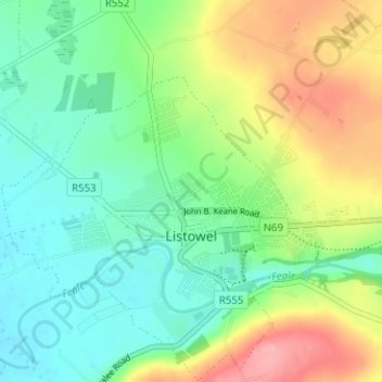
Nom : Carte topographique Listowel, altitude, relief.
Altitude moyenne : 43 m
Altitude minimum : 7 m
Altitude maximum : 109 m
Autres cartes topographiques
Cliquez sur une carte pour visualiser sa topographie, son altitude et son relief.
Great Blasket Island
Great Blasket Island, Toghroinn ceantair Dún Chaoin, Kenmare Municipal District, County Kerry, Munster, Ireland
Altitude moyenne : 21 m
Killarney
Killarney, Killarney Urban ED, Killarney Municipal District, County Kerry, Munster, Ireland
Altitude moyenne : 39 m
Listowel
Ireland > County Kerry > Listowel
Listowel, Listowel Municipal District, County Kerry, Munster, V31 YK58, Ireland
Altitude moyenne : 44 m
Caherdaniel
Ireland > County Kerry > Caherdaniel
Caherdaniel, Kenmare Municipal District, County Kerry, Munster, Ireland
Altitude moyenne : 108 m