
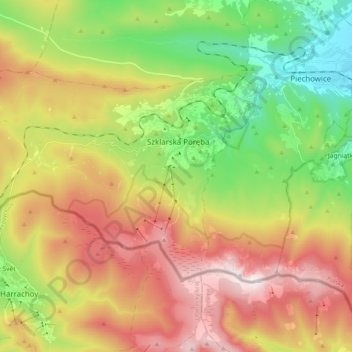
Carte topographique Szklarska Poręba
Carte interactive
Cliquez sur la carte pour afficher l’altitude.
À propos de cette carte
Nom : Carte topographique Szklarska Poręba, altitude, relief.
Altitude moyenne : 891 m
Altitude minimum : 485 m
Altitude maximum : 1 486 m
Autres cartes topographiques
Cliquez sur une carte pour visualiser sa topographie, son altitude et son relief.
Kowary
Poland > Lower Silesian Voivodeship > Karkonosze County > Kowary
Kowary, Karkonosze County, Lower Silesian Voivodeship, 58-530, Poland
Altitude moyenne : 698 m
Karpacz
Poland > Lower Silesian Voivodeship > Karkonosze County
Karpacz, Karkonosze County, Lower Silesian Voivodeship, 58-540, Poland
Altitude moyenne : 913 m
Śnieżka / Sněžka
Poland > Lower Silesian Voivodeship > Karkonosze County > Karpacz
Śnieżka / Sněžka, Karpacz, Karkonosze County, Lower Silesian Voivodeship, 58-540, Poland
Altitude moyenne : 1 262 m
Szklarka
Poland > Lower Silesian Voivodeship > Karkonosze County > Piechowice
Szklarka, Piechowice, Karkonosze County, Lower Silesian Voivodeship, 58-580, Poland
Altitude moyenne : 663 m
Trzcińsko
Poland > Lower Silesian Voivodeship > Karkonosze County > Trzcińsko
Trzcińsko, gmina Janowice Wielkie, Karkonosze County, Lower Silesian Voivodeship, 58-520, Poland
Altitude moyenne : 420 m
Karpacz
Poland > Lower Silesian Voivodeship > Karkonosze County > Karpacz
Karpacz, Karkonosze County, Lower Silesian Voivodeship, 58-540, Poland
Altitude moyenne : 933 m