
Faire un don
Équipez-vous pour votre prochaine aventure :
En tant que Partenaire Amazon, ce site perçoit une commission sur les achats éligibles sans surcoût pour vous.
Carte topographique St. Jakob
Cliquez sur la carte pour afficher l’altitude.
Faire un don
Équipez-vous pour votre prochaine aventure :
En tant que Partenaire Amazon, ce site perçoit une commission sur les achats éligibles sans surcoût pour vous.
À propos de cette carte
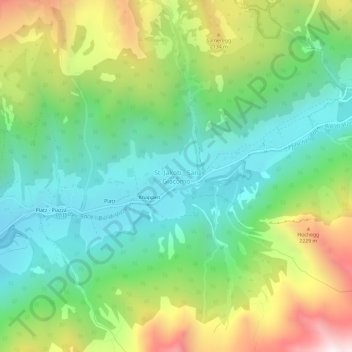
Nom : Carte topographique St. Jakob, altitude, relief.
Lieu : St. Jakob, Pfitsch, Wipptal, Bozen, Trentino-Südtirol, Italien (46.94902 11.58274 46.98902 11.62274)
Altitude moyenne : 1 809 m
Altitude minimum : 1 399 m
Altitude maximum : 2 590 m
Faire un don
Équipez-vous pour votre prochaine aventure :
En tant que Partenaire Amazon, ce site perçoit une commission sur les achats éligibles sans surcoût pour vous.
Autres cartes topographiques
Cliquez sur une carte pour visualiser sa topographie, son altitude et son relief.
Pfitsch
Italien > Trentino-Südtirol > Bozen > Pfitsch
Das erste Teilstück der Berge, die das Pfitscher Tal im Nordwesten und Norden begrenzen, ist der Tuxer Kamm. Zu den bedeutendsten Gipfeln hier zählen die Weißspitze (2714 m), das Hühnerspiel (2790 m), die Rollspitze (2776 m), die Kalkwandstange (2386 m), die Flatschspitze (2570 m) und der Wolfendorn (2776…
Altitude moyenne : 1 953 m