
Carte topographique Hat Yai
Carte interactive
Cliquez sur la carte pour afficher l’altitude.
À propos de cette carte
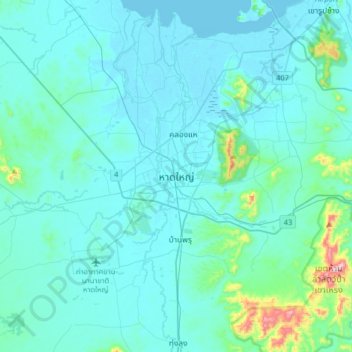
Nom : Carte topographique Hat Yai, altitude, relief.
Lieu : Hat Yai, Kho Hong, Songkhla Province, Thailand (6.84746 100.30899 7.16746 100.62899)
Altitude moyenne : 47 m
Altitude minimum : -2 m
Altitude maximum : 524 m
Autres cartes topographiques
Cliquez sur une carte pour visualiser sa topographie, son altitude et son relief.
Cat Island
Thailand > Songkhla Province > Songkhla
Cat Island, Songkhla, Songkhla Province, Thailand
Altitude moyenne : 0 m