
Carte topographique Raren
Carte interactive
Cliquez sur la carte pour afficher l’altitude.
À propos de cette carte
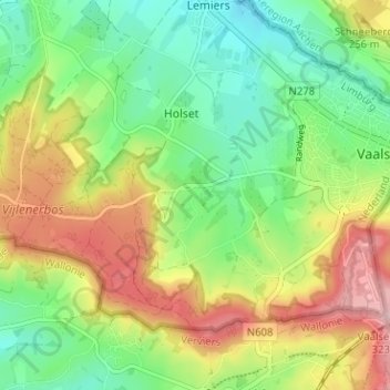
Nom : Carte topographique Raren, altitude, relief.
Lieu : Raren, Vaals, Limburg, Nederland, 6291 NN, Nederland (50.74680 5.97004 50.78680 6.01004)
Altitude moyenne : 222 m
Altitude minimum : 146 m
Altitude maximum : 332 m
Autres cartes topographiques
Cliquez sur une carte pour visualiser sa topographie, son altitude et son relief.
Hoogste Punt van Nederland
Hoogste Punt van Nederland, Vaals, Limburg, Nederland, 6291 BX, Nederland
Altitude moyenne : 272 m
Kasteel Vaalsbroek
Kasteel Vaalsbroek, Vaalsbroek, Vaals, Limburg, Nederland, 6291NH, Nederland
Altitude moyenne : 219 m