
Carte topographique Hoogste Punt van Nederland
Carte interactive
Cliquez sur la carte pour afficher l’altitude.
À propos de cette carte
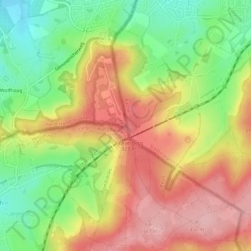
Nom : Carte topographique Hoogste Punt van Nederland, altitude, relief.
Altitude moyenne : 272 m
Altitude minimum : 190 m
Altitude maximum : 347 m
Autres cartes topographiques
Cliquez sur une carte pour visualiser sa topographie, son altitude et son relief.
Kasteel Vaalsbroek
Kasteel Vaalsbroek, Vaalsbroek, Vaals, Limburg, Nederland, 6291NH, Nederland
Altitude moyenne : 219 m