
Carte topographique Bang Kho Laem District
Carte interactive
Cliquez sur la carte pour afficher l’altitude.
À propos de cette carte
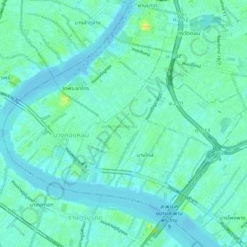
Nom : Carte topographique Bang Kho Laem District, altitude, relief.
Lieu : Bang Kho Laem District, Bangkok, 10120, Thailand (13.68278 100.48984 13.71234 100.53110)
Altitude moyenne : 6 m
Altitude minimum : -1 m
Altitude maximum : 21 m
Autres cartes topographiques
Cliquez sur une carte pour visualiser sa topographie, son altitude et son relief.
Phra Khanong District
Phra Khanong District, Bangkok, 10260, Thailand
Altitude moyenne : 4 m
Lat Krabang District
Lat Krabang District, Bangkok, 10520, Thailand
Altitude moyenne : 3 m
Bang Rak District
Bang Rak District, Bangkok, 10500, Thailand
Altitude moyenne : 8 m
Khlong Sam Wa District
Khlong Sam Wa District, Bangkok, 10510, Thailand
Altitude moyenne : 4 m
Khlong Tan Nuea Subdistrict
Thailand > Bangkok > Khlong Tan Nuea Subdistrict
Khlong Tan Nuea Subdistrict, Watthana District, Bangkok, 10110, Thailand
Altitude moyenne : 6 m
Lat Yao Subdistrict
Thailand > Bangkok > Lat Yao Subdistrict
Lat Yao Subdistrict, Chatuchak District, Bangkok, 10900, Thailand
Altitude moyenne : 5 m
Thanon Nakhon Chai Si Subdistrict
Thailand > Bangkok > Thanon Nakhon Chai Si Subdistrict
Thanon Nakhon Chai Si Subdistrict, Dusit District, Bangkok, 10300, Thailand
Altitude moyenne : 6 m
Arokaya Park, 77th Anniversary of Kasetsart University
Arokaya Park, 77th Anniversary of Kasetsart University, Kaset, Bangkok, Chatuchak District, Bangkok, 10900, Thailand
Altitude moyenne : 5 m
Lumphini Subdistrict
Thailand > Bangkok > Lumphini Subdistrict
Lumphini Subdistrict, Pathum Wan District, Bangkok, 10330, Thailand
Altitude moyenne : 9 m
Chom Thong District
Chom Thong District, Bangkok, 10150, Thailand
Altitude moyenne : 5 m