
Carte topographique Stavelot
Carte interactive
Cliquez sur la carte pour afficher l’altitude.
À propos de cette carte
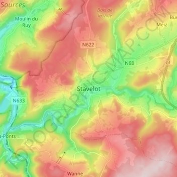
Nom : Carte topographique Stavelot, altitude, relief.
Lieu : Stavelot, Verviers, Liège, Wallonia, 4970, Belgium (50.35424 5.89103 50.43424 5.97103)
Altitude moyenne : 401 m
Altitude minimum : 219 m
Altitude maximum : 585 m
Stavelot has an oceanic climate influenced by its high elevation and inland position towards a more continental type by Belgian standards. Being located at a lower elevation than neighbouring village Malmedy at the other end of the original layout of the Spa-Francorchamps race track, Stavelot is slightly milder, drier and sunnier than Malmedy year round.
Autres cartes topographiques
Cliquez sur une carte pour visualiser sa topographie, son altitude et son relief.
Cronchamps
Belgium > Liège > Verviers > Stavelot
Cronchamps, Stavelot, Verviers, Liège, Wallonia, 4970, Belgium
Altitude moyenne : 506 m
Francorchamps
Belgium > Liège > Verviers > Stavelot
Francorchamps, Stavelot, Verviers, Liège, Wallonia, 4970, Belgium
Altitude moyenne : 482 m