
Carte topographique Petit Coo
Carte interactive
Cliquez sur la carte pour afficher l’altitude.
À propos de cette carte
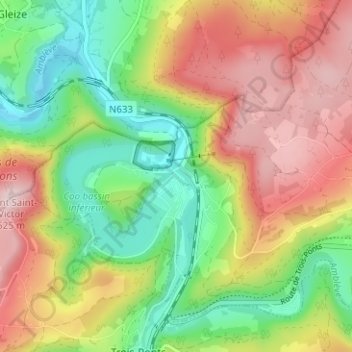
Nom : Carte topographique Petit Coo, altitude, relief.
Lieu : Petit Coo, Stavelot, Verviers, Liège, Wallonia, 4970, Belgium (50.37271 5.85704 50.41271 5.89704)
Altitude moyenne : 349 m
Altitude minimum : 207 m
Altitude maximum : 517 m
Autres cartes topographiques
Cliquez sur une carte pour visualiser sa topographie, son altitude et son relief.
Cronchamps
Belgium > Liège > Verviers > Stavelot
Cronchamps, Stavelot, Verviers, Liège, Wallonia, 4970, Belgium
Altitude moyenne : 506 m
Francorchamps
Belgium > Liège > Verviers > Stavelot
Francorchamps, Stavelot, Verviers, Liège, Wallonia, 4970, Belgium
Altitude moyenne : 482 m