
Carte topographique Polkton Township
Carte interactive
Cliquez sur la carte pour afficher l’altitude.
À propos de cette carte
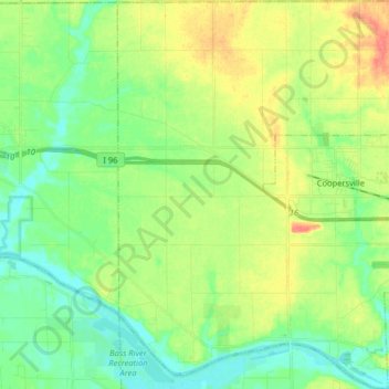
Nom : Carte topographique Polkton Township, altitude, relief.
Lieu : Polkton Township, Ottawa County, Michigan, United States (43.00166 -86.02702 43.11886 -85.90674)
Altitude moyenne : 195 m
Altitude minimum : 175 m
Altitude maximum : 228 m
Autres cartes topographiques
Cliquez sur une carte pour visualiser sa topographie, son altitude et son relief.
Georgetown Charter Township
United States > Michigan > Ottawa County
Georgetown Charter Township, Ottawa County, Michigan, 49428, United States
Altitude moyenne : 199 m
Port Sheldon
United States > Michigan > Ottawa County
Port Sheldon, Port Sheldon Township, Ottawa County, Michigan, United States
Altitude moyenne : 185 m
Coopersville
United States > Michigan > Ottawa County
Coopersville, Ottawa County, Michigan, 49404, United States
Altitude moyenne : 200 m
Holland
United States > Michigan > Ottawa County > Holland
Holland, Ottawa County, Michigan, 49423, United States
Altitude moyenne : 199 m
Allendale
United States > Michigan > Ottawa County > Allendale
Allendale, Allendale Charter Township, Ottawa County, Michigan, 49401, United States
Altitude moyenne : 195 m
Chester Township
United States > Michigan > Ottawa County
Chester Township, Ottawa County, Michigan, 49403, United States
Altitude moyenne : 233 m
Zeeland
United States > Michigan > Ottawa County
Zeeland, Ottawa County, Michigan, 49464, United States
Altitude moyenne : 192 m