
Carte topographique Zeeland
Carte interactive
Cliquez sur la carte pour afficher l’altitude.
À propos de cette carte
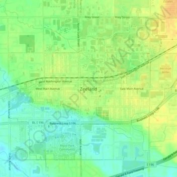
Nom : Carte topographique Zeeland, altitude, relief.
Lieu : Zeeland, Ottawa County, Michigan, 49464, United States (42.79790 -86.03850 42.82690 -85.98896)
Altitude moyenne : 192 m
Altitude minimum : 178 m
Altitude maximum : 203 m
According to the United States Census Bureau, the city has a total area of 3.01 square miles (7.80 km2), of which 2.99 square miles (7.74 km2) is land and 0.02 square miles (0.05 km2) is water. The town itself is located on a hill, giving the city a higher elevation compared to the surrounding township land. Much of the outlying areas contain farmland and forest.
Autres cartes topographiques
Cliquez sur une carte pour visualiser sa topographie, son altitude et son relief.
Georgetown Charter Township
United States > Michigan > Ottawa County
Georgetown Charter Township, Ottawa County, Michigan, 49428, United States
Altitude moyenne : 199 m
Port Sheldon
United States > Michigan > Ottawa County
Port Sheldon, Port Sheldon Township, Ottawa County, Michigan, United States
Altitude moyenne : 185 m
Polkton Township
United States > Michigan > Ottawa County
Polkton Township, Ottawa County, Michigan, United States
Altitude moyenne : 195 m
Coopersville
United States > Michigan > Ottawa County
Coopersville, Ottawa County, Michigan, 49404, United States
Altitude moyenne : 200 m
Holland
United States > Michigan > Ottawa County > Holland
Holland, Ottawa County, Michigan, 49423, United States
Altitude moyenne : 199 m
Allendale
United States > Michigan > Ottawa County > Allendale
Allendale, Allendale Charter Township, Ottawa County, Michigan, 49401, United States
Altitude moyenne : 195 m
Chester Township
United States > Michigan > Ottawa County
Chester Township, Ottawa County, Michigan, 49403, United States
Altitude moyenne : 233 m