
Carte topographique Priory
Carte interactive
Cliquez sur la carte pour afficher l’altitude.
À propos de cette carte
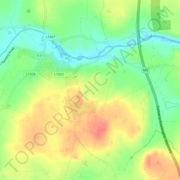
Nom : Carte topographique Priory, altitude, relief.
Altitude moyenne : 63 m
Altitude minimum : 37 m
Altitude maximum : 88 m
Autres cartes topographiques
Cliquez sur une carte pour visualiser sa topographie, son altitude et son relief.
Newfarm
Newfarm, The Rower, The Municipal District of Callan — Thomastown, County Kilkenny, Leinster, Ireland
Altitude moyenne : 33 m
The Municipal District of Piltown
The Municipal District of Piltown, County Kilkenny, Leinster, Ireland
Altitude moyenne : 89 m
The Municipal District of Callan — Thomastown
The Municipal District of Callan — Thomastown, County Kilkenny, Leinster, Ireland
Altitude moyenne : 100 m
Kilkenny
Ireland > County Kilkenny > Kilkenny
Kilkenny, The Municipal District of Kilkenny City, County Kilkenny, Leinster, Ireland
Altitude moyenne : 62 m