
Carte topographique Newfarm
Carte interactive
Cliquez sur la carte pour afficher l’altitude.
À propos de cette carte
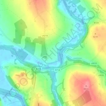
Nom : Carte topographique Newfarm, altitude, relief.
Altitude moyenne : 33 m
Altitude minimum : -8 m
Altitude maximum : 81 m
Autres cartes topographiques
Cliquez sur une carte pour visualiser sa topographie, son altitude et son relief.
The Municipal District of Piltown
The Municipal District of Piltown, County Kilkenny, Leinster, Ireland
Altitude moyenne : 89 m
The Municipal District of Callan — Thomastown
The Municipal District of Callan — Thomastown, County Kilkenny, Leinster, Ireland
Altitude moyenne : 100 m
Priory
Priory, Kells, The Municipal District of Callan — Thomastown, County Kilkenny, Leinster, R95 EFR9, Ireland
Altitude moyenne : 63 m
Kilkenny
Ireland > County Kilkenny > Kilkenny
Kilkenny, The Municipal District of Kilkenny City, County Kilkenny, Leinster, Ireland
Altitude moyenne : 62 m