
Carte topographique Royal Pines
Carte interactive
Cliquez sur la carte pour afficher l’altitude.
À propos de cette carte
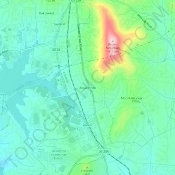
Nom : Carte topographique Royal Pines, altitude, relief.
Altitude moyenne : 700 m
Altitude minimum : 637 m
Altitude maximum : 903 m
Royal Pines is located in southern Buncombe County at 35°28′39″N 82°30′35″W / 35.47750°N 82.50972°W / 35.47750; -82.50972 (35.477386, -82.509833). It is bordered to the west by U.S. Route 25A and the city limits of Asheville, and to the northeast by Mills Gap Road. Brown Mountain, with an elevation of 2,996 feet (913 m), occupies the center of the CDP.
Autres cartes topographiques
Cliquez sur une carte pour visualiser sa topographie, son altitude et son relief.
Biltmore Village
United States > North Carolina > Buncombe County > Asheville
Biltmore Village, Asheville, Buncombe County, North Carolina, 28802, United States
Altitude moyenne : 642 m
Albemarle
United States > North Carolina > Buncombe County > Asheville
Albemarle, Asheville, Buncombe County, North Carolina, 28802, United States
Altitude moyenne : 718 m
Biltmore
United States > North Carolina > Buncombe County > Asheville
Biltmore, Asheville, Buncombe County, North Carolina, 28803, United States
Altitude moyenne : 650 m
Redwood Village
United States > North Carolina > Buncombe County > Asheville
Redwood Village, Asheville, Buncombe County, North Carolina, 28805, United States
Altitude moyenne : 657 m
Aston Park
United States > North Carolina > Buncombe County > Asheville > River Arts District
Aston Park, River Arts District, Asheville, Buncombe County, North Carolina, 28801, United States
Altitude moyenne : 641 m
Kenilworth
United States > North Carolina > Buncombe County > Asheville
Kenilworth, Asheville, Buncombe County, North Carolina, 28802, United States
Altitude moyenne : 648 m
Deaver View
United States > North Carolina > Buncombe County > Asheville
Deaver View, Asheville, Buncombe County, North Carolina, 28806, United States
Altitude moyenne : 678 m