
Carte topographique Redwood Village
Carte interactive
Cliquez sur la carte pour afficher l’altitude.
À propos de cette carte
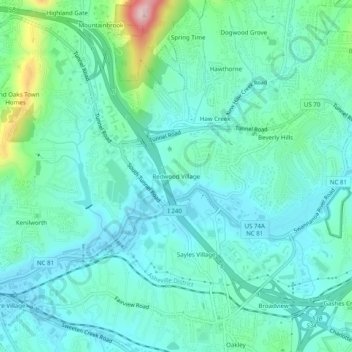
Nom : Carte topographique Redwood Village, altitude, relief.
Altitude moyenne : 657 m
Altitude minimum : 607 m
Altitude maximum : 861 m
Autres cartes topographiques
Cliquez sur une carte pour visualiser sa topographie, son altitude et son relief.
Biltmore Village
United States > North Carolina > Buncombe County > Asheville
Biltmore Village, Asheville, Buncombe County, North Carolina, 28802, United States
Altitude moyenne : 642 m
Albemarle
United States > North Carolina > Buncombe County > Asheville
Albemarle, Asheville, Buncombe County, North Carolina, 28802, United States
Altitude moyenne : 718 m
Royal Pines
United States > North Carolina > Buncombe County > Asheville
Royal Pines, Asheville, Buncombe County, North Carolina, 28776, United States
Altitude moyenne : 700 m
Biltmore
United States > North Carolina > Buncombe County > Asheville
Biltmore, Asheville, Buncombe County, North Carolina, 28803, United States
Altitude moyenne : 650 m
Aston Park
United States > North Carolina > Buncombe County > Asheville > River Arts District
Aston Park, River Arts District, Asheville, Buncombe County, North Carolina, 28801, United States
Altitude moyenne : 641 m
Kenilworth
United States > North Carolina > Buncombe County > Asheville
Kenilworth, Asheville, Buncombe County, North Carolina, 28802, United States
Altitude moyenne : 648 m
Deaver View
United States > North Carolina > Buncombe County > Asheville
Deaver View, Asheville, Buncombe County, North Carolina, 28806, United States
Altitude moyenne : 678 m