
Carte topographique Rondón
Carte interactive
Cliquez sur la carte pour afficher l’altitude.
À propos de cette carte
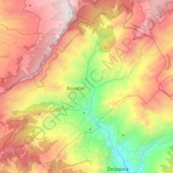
Nom : Carte topographique Rondón, altitude, relief.
Lieu : Rondón, Lengupá, Boyacá, Colombia (5.28061 -73.28690 5.43859 -73.12249)
Altitude moyenne : 2 472 m
Altitude minimum : 1 303 m
Altitude maximum : 3 542 m
Rondón is a town and municipality in the Márquez Province, part of Boyacá Department, Colombia. The urban centre of Rondón is situated at an altitude of 2,075 metres (6,808 ft) on the Altiplano Cundiboyacense in the Colombian Eastern Ranges of the Andes. It is 61 kilometres (38 mi) away from the departmental capital Tunja. Rondón borders Viracachá and Siachoque in the north, Zetaquirá and Ramiriquí in the south, Pesca in the east and Ramiriquí and Ciénega in the west.
Autres cartes topographiques
Cliquez sur une carte pour visualiser sa topographie, son altitude et son relief.
Gachantivá
Gachantivá, Ricaurte, Boyacá, RAP (Especial) Central, Colombia
Altitude moyenne : 2 365 m
Iguaque
Colombia > Boyacá > Villa de Leyva > VILLA DE LEYVA
Iguaque, VILLA DE LEYVA, Villa de Leyva, Ricaurte, Boyacá, RAP (Especial) Central, 154001, Colombia
Altitude moyenne : 2 337 m
Villa de Leyva
Colombia > Boyacá > Villa de Leyva
Villa de Leyva, Boyacá, 15401, Colombia
Altitude moyenne : 2 673 m
Paramo de la Rusia
Paramo de la Rusia, Duitama, Tundama, Boyacá, Colombia
Altitude moyenne : 3 624 m
Guacamayas
Guacamayas, Gutiérrez, Boyacá, 151220, Colombia
Altitude moyenne : 2 641 m
Miraflores
Miraflores, Lengupá, Boyacá, RAP (Especial) Central, Colombia
Altitude moyenne : 1 943 m
Labranzagrande
Labranzagrande, La Libertad, Boyacá, Colombia
Altitude moyenne : 1 978 m
Cerro El Gaital
Cerro El Gaital, Labranzagrande, Boyacá, Colombia
Altitude moyenne : 2 178 m