
Carte topographique Gachantivá
Carte interactive
Cliquez sur la carte pour afficher l’altitude.
À propos de cette carte
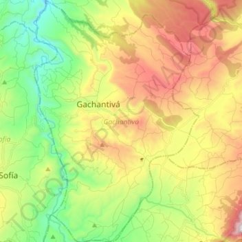
Nom : Carte topographique Gachantivá, altitude, relief.
Lieu : Gachantivá, Ricaurte, Boyacá, RAP (Especial) Central, Colombia (5.67772 -73.58273 5.80714 -73.49401)
Altitude moyenne : 2 365 m
Altitude minimum : 1 846 m
Altitude maximum : 3 079 m
Gachantivá is a town and municipality in the Ricaurte Province, part of the Colombian department of Boyacá. Gachantivá is located at altitudes ranging from 2,000 metres (6,600 ft) to 3,300 metres (10,800 ft) on the Altiplano Cundiboyacense and borders Villa de Leyva in the south, Santa Sofía in the west, Arcabuco in the east and Moniquirá in the north.
Autres cartes topographiques
Cliquez sur une carte pour visualiser sa topographie, son altitude et son relief.
Iguaque
Colombia > Boyacá > Villa de Leyva > VILLA DE LEYVA
Iguaque, VILLA DE LEYVA, Villa de Leyva, Ricaurte, Boyacá, RAP (Especial) Central, 154001, Colombia
Altitude moyenne : 2 337 m
Villa de Leyva
Colombia > Boyacá > Villa de Leyva
Villa de Leyva, Boyacá, 15401, Colombia
Altitude moyenne : 2 673 m
Paramo de la Rusia
Paramo de la Rusia, Duitama, Tundama, Boyacá, Colombia
Altitude moyenne : 3 624 m
Guacamayas
Guacamayas, Gutiérrez, Boyacá, 151220, Colombia
Altitude moyenne : 2 641 m
Miraflores
Miraflores, Lengupá, Boyacá, RAP (Especial) Central, Colombia
Altitude moyenne : 1 943 m
Labranzagrande
Labranzagrande, La Libertad, Boyacá, Colombia
Altitude moyenne : 1 978 m
Cerro El Gaital
Cerro El Gaital, Labranzagrande, Boyacá, Colombia
Altitude moyenne : 2 178 m