
Carte topographique Goris
Carte interactive
Cliquez sur la carte pour afficher l’altitude.
Goris
Goris is situated in the valley of Goris River, also known as Vararak River. The valley is surrounded with the Zangezur Mountains. The town has an average elevation of 1,385 metres above sea level. The surrounding mountains are famous for their medieval cave-dwellings carved out of the soft rock in the southern and eastern parts of the town. The Goris Wildlife Sanctuary is situated at the southeast of the town at a height ranging between 1400 and 2800 meters above sea level, covering an area of 18.5 km². Caucasian grouse, roe deer and brown bear are among the notable animals in the sanctuary.
À propos de cette carte
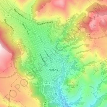
Nom : Carte topographique Goris, altitude, relief.
Lieu : Goris, Goris community, Syunik Province, Armenia (39.49195 46.31325 39.52979 46.35320)
Altitude moyenne : 1 513 m
Altitude minimum : 1 210 m
Altitude maximum : 1 865 m
Autres cartes topographiques
Cliquez sur une carte pour visualiser sa topographie, son altitude et son relief.
Kapan
The town is about 80 km (50 mi) north of the Iranian border. With a height of 3201 meters, Mount Khustup is the highest peak of the region. The elevation of Kapan is 750–1050 meters above sea level, with an average height of 910 meters. Two tributaries of the Voghji River, Vachagan and Kavart, flow through…
Altitude moyenne : 1 110 m
Halidzor
Geographically, Halidzor is located near the left bank of the Vorotan River, at an altitude of 1300-1350 m above sea level. The regional center of Syunik province - the city of Kapan, is 62 km away. The nearest town is Goris, which is 12 km to the southwest.
Altitude moyenne : 1 326 m