
Carte topographique Halidzor
Carte interactive
Cliquez sur la carte pour afficher l’altitude.
À propos de cette carte
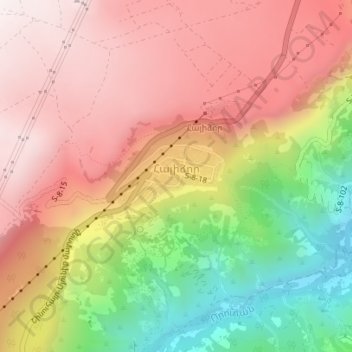
Nom : Carte topographique Halidzor, altitude, relief.
Lieu : Halidzor, Tatev community, Syunik Province, Armenia (39.40967 46.28911 39.41453 46.29972)
Altitude moyenne : 1 326 m
Altitude minimum : 821 m
Altitude maximum : 1 692 m
Geographically, Halidzor is located near the left bank of the Vorotan River, at an altitude of 1300-1350 m above sea level. The regional center of Syunik province - the city of Kapan, is 62 km away. The nearest town is Goris, which is 12 km to the southwest.
Autres cartes topographiques
Cliquez sur une carte pour visualiser sa topographie, son altitude et son relief.
Tolors
Tolors, Sisian Community, Syunik Province, Armenia
Altitude moyenne : 1 701 m
Kapan
Armenia > Syunik Province > Kapan
Kapan, Kapan Community, Syunik Province, Armenia
Altitude moyenne : 1 026 m
Tatev
Tatev, Tatev community, Syunik Province, 3218, Armenia
Altitude moyenne : 1 493 m
Goris
Armenia > Syunik Province > Goris
Goris, Goris Community, Syunik Province, Armenia
Altitude moyenne : 1 513 m
Dastakert
Armenia > Syunik Province > Dastakert
Dastakert, Sisian Community, Syunik Province, Armenia
Altitude moyenne : 2 067 m
Kapan
Armenia > Syunik Province > Kapan
Kapan, Syunik Province, 3304, Armenia
Altitude moyenne : 1 021 m
Agarak
Armenia > Syunik Province > Agarak
Agarak, Syunik Province, 3403, Armenia
Altitude moyenne : 708 m
Salvard
Salvard, Sisian Community, Syunik Province, Armenia
Altitude moyenne : 2 031 m